Portlanders have two incredible treasures that are crossed thousands of times daily. Yet, they’re constantly overlooked and almost never accessed.
Table of Contents

Though I’ll be pointing out many opportunities presented by passenger ferry service, this long post is equally focused on *accessing, activating, appreciating and protecting* the continent’s most spectacular major metropolitan river system.
Until very recently, like everyone else, I’d call Portland “Bridgetown” (or, of course, “Stumptown”) when thinking of our river-themed moniker. But I’ve now realized that Portland is much more of a RIVER city than merely “bridgetown.” Let Pittsburgh keep the bridge town crown. 🙂
MAIN THEMES OF THIS POST
This post has many sections; they’re all linked from the Table of Contents. But I’m focusing on several main themes:
Theme 1: Introducing people to numerous sections of the most beautiful urban river confluence in the U.S.
If no other themes interest you, at least you’ll enjoy the beautiful photos throughout this post! I guarantee that you’ll see at least a few previously unseen scenes! 🙂 I *love* exploring Portland’s greatest (and by far the most overlooked) urban treasure.

Theme 2: The incredible lack of ACCESS to the Willamette

Theme 3: *Activating* the waterfront at key urban locations.
Portland is rightfully lauded for being the world’s first city to replace a downtown freeway with a park. But nearly 50 years later, all of Waterfront Park beyond the seawall (not to mention all of Naito Parkway) suffers from a tremendous lack of activation.
Note: the final section will have many great examples of riverfront activation from around the world.

Theme 4: Showcasing some of the beautiful multi-use trails along the Willamette – and highlighting gaps, needs and opportunities.

Theme 5: Introducing several *solutions* for activating key waterfront locations
A passenger ferry system would not only help activate numerous waterfront stops. It would re-connect the region’s three most historic cities in the best possible way, get people familiar with our incredibly beautiful rivers, help educate people about the incredible cultures that have depended on our rivers for many thousands of years, and create thousands of future champions for restoring and celebrating every aspect of the Willamette and Columbia.

Note: clicking on any image will open the full-sized version in a new tab for you to see the beautiful rivers and shorelines way better!

INTRODUCTION
[Note: you can always skip to the Table of Contents, which links to each section of this post.]
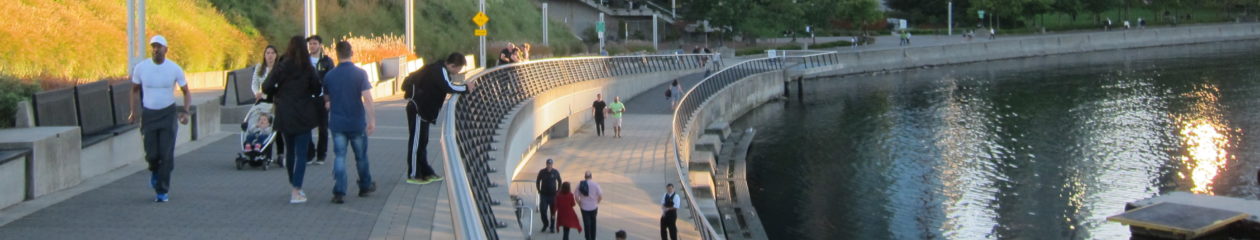
Portlanders LOVE accessing the river when actually given opportunities, such as during the amazing annual “Big Float.”
[Obvious disclaimer: all these shots of large groups of people enjoying cities and nature together were taken long before “social distancing” was in everyone’s vernacular!]

The Portland Saturday Market brings many thousands of locals and visitors to the downtown waterfront every Saturday and Sunday from March through December. It’s the largest continuously operating open-air arts and crafts market in the country.

Portlanders are extremely active. They LOVE walking, biking, taking transit and supporting countless urban attractions. But other than the very popular seawall path, Portland’s waterfront “Central Park” offers almost nothing but 37 acres of empty, lifeless grass.
Portland’s beautiful, creatively designed food cart pods are unparalleled worldwide (Austin is about the only other city with anything even remotely close). Yet, there isn’t a SINGLE food cart (or cafe, restaurant, etc) in the *entire* 8000-foot-long park!

Thus, all you see every day (other than when enormous events take over and privatize the park) are endless empty stretches like this. Click on the image to get the FULL depressing effect. Most Portlanders (and obviously visitors) have NO idea how stunning the Willamette and Columbia rivers are, because THIS is how everyone is introduced to the river:
There are also shockingly few places along the entire Willamette River where Portlanders are able to actually touch it! The few access points are very popular. Shown below is the only place downtown where it’s even possible to physically access the river on foot (Poet’s Beach notwithstanding; it’s really not downtown):

Even witches are dying to find a place to simply put in a kayak! 🙂 Even in the highly populated South Waterfront neighborhood, there isn’t a single place where you can even touch the river! That’s utterly ridiculous and needs to be fixed NOW.

NOW… What if there were a super fun transportation system–already in use in great river cities all over the world–that would *finally* allow Portlanders to truly experience our glorious Willamette and Columbia rivers, while providing low-to-no-emissions transportation with 99% reliability from Oregon City all the way up to Vancouver, Washington?!?

That’s where the Frog Ferry comes in! 🙂 This blog post will highlight the stations along the proposed route of this passenger ferry (all of which have *incredible* potential).
Just as importantly, I will highlight the amazing *scenery* that few locals (and almost no visitors) witness along America’s most beautiful major metropolitan river corridor. Stopping at each of Frog Ferry’s docks, from north to south, will be a fun way to tell the larger story of these incredible and highly under-appreciated rivers.

MAIN CONTENTS
Rediscovering Portland’s greatest treasure, from north to south:
- Vancouver
- Wait: What’s Frog Ferry? What’s the idea behind it?
- Kelley Point Park and the Columbia Slough
- Scenic Timeout #1: Houseboats!
- St Johns: Cathedral Park
- Swan Island
- Scenic Timeout #2: Riverside bike trails
- Convention Center
- Salmon Street (downtown Portland)
- Scenic Timeout #3: Bridge views!
- OMSI
- OHSU
- Scenic Timeout #4: Sunset & night views!
- Milwaukie
- Lake Oswego
- Scenic Timeout #5: Mt Hood views!
- Oregon City
- A final look at Portland’s amazing scenery viewed from the river
- How other cities are activating their waterfronts
- Great streets near waterfronts are for PEOPLE, not CARS
Vancouver
Vancouver recently converted a former 32-acre abandoned industrial area into the most beautiful, activated and exciting urban waterfront in the Portland area. I cannot imagine a more scenic (and up to 99% reliable) route to Vancouver from downtown Portland than taking a passenger ferry there!

Even in January, Vancouver’s evolving downtown waterfront can be super inviting. And the restaurants are packed all the time. Downtown Portland needs to *massively* redesign both Waterfront Park and SW Naito Parkway to invite PEOPLE, rather than cars and geese! 🙂

Driving from downtown Portland to Vancouver could take 20 minutes or 90 minutes–and transit takes much longer still.
But the Frog Ferry would take 38 minutes (nonstop), every single time (50 minutes with two stops). People mainly want *predictable* and *reliable* transportation options.
Plus, NO other form of transportation is as scenic and relaxing as ferry travel. Ask anyone who’s ever taken the ferry from Seattle to Bainbridge or Bremerton!

If Portland had a ferry solely connecting downtown and Vancouver’s waterfront, that *alone* would be worth it. And future sections will show the incredible beauty found along the entire route.
Nearly 1500 people commute daily from Vancouver to OHSU alone. They could sit in endless traffic and concrete – or take a scenic river ride that will typically take way less time.

Vancouver recognizes that activating its downtown waterfront by providing permanent amenities and a mixed-use neighborhood makes the waterfront so much more enjoyable to visit. A passenger ferry would be a major catalyst in helping Portland do the same.


Wait: What’s Frog Ferry? What’s the idea behind it?
I could easily write a separate enormous blog post about my friend Susan Bladholm’s incredible vision for passenger ferry service, but I’ll let her Frog Ferry website do most of the talking. 🙂

But here are “just a few” things to highlight and consider:
- Portland is America’s largest major river city without ferry service
- Frog Ferry would provide *predictable* travel times north and south, for once! And it would be incredibly reliable and resilient
- Ferries would *complement* all other transportation modes
- The public subsidy per ride is a tiny fraction of what the public pays per bus and MAX ride (despite what’s commonly believed!) – and that’s only for the *operational* side of TriMet
- Transit subsidies hide the costs of *infrastructure* from subsidy calculations. We may never truly know how much we’re subsidizing ANY form of transportation.
- The metro area’s three oldest and by far most historic cities in every way (Oregon City, Portland and Vancouver) would finally be linked once again by water, as they should forever be joined
- Waterfront Park would *finally* be ACTIVATED!
- North America’s most beautiful major metropolitan river network would be seen with totally new eyes by millions of people – and it would create MANY future stewards of its ecosystem
- None other than *Walt Whitman* got his greatest inspiration while riding the *ferry* daily from Brooklyn to Manhattan! No bus ride can possibly compare to a ferry ride downtown.
- When all other transportation breaks down in a disaster,
FERRIES and BIKES will always be reliable! - ONE collision can easily tie up *many thousands* of travelers for an hour or an entire afternoon. This would NEVER happen on *water-based* travel
- San Francisco Bay Ferry arose following the devastating 1989 earthquake, and its popularity has increased ever since!
- Frog Ferry will meet the maximum-one-foot-wake requirement
- Frog Ferry is designed to fit under ALL of the Willamette River bridges. Only the Steel Bridge (with the lowest clearance) would have to be raised on rare occasions when the river is at its highest levels
- The system could immediately be scaled up in the event that emergency response support is needed
- Frog Ferry could be implemented in phases, starting with as little as a route from St. Johns directly to OHSU
- Passenger ferries offer almost innumerable permutations and combinations in their routes, including “express routes” that are impossible to do with MAX trains (due to – and I’ll keep emphasizing this – the route being *water*!)
- If you need to quickly or temporarily add tons of capacity between two stops, it’s easy to do; there’s always room!
- We have a massive untapped transportation corridor running straight down the center of Portland, and there’s plenty of room for all watercraft
- Frog Ferry could be completely electrified within a decade and provide zero-emissions travel along its entire route
- Its propulsion system is designed to be replaced wholesale once it switches to 100% battery power; this instant propulsion swap is not possible on TriMet buses
- There’s no concrete to pour! The river IS the transportation network, which people have been using for thousands of years!
- If you need a parallel route, the WATER already exists! You don’t need to build a parallel set of tracks or purchase $billions worth of right-of-way and spend $billions more to widen the corridor. Again, the WATER is your already-built-in corridor.
- There’s no “rush hour” when the route is, once again, *water*
- Not a single pothole will ever need to be fixed
- I’m a big fan of Portland-based Depave – and what could be more “parking lots to paradise” than traveling over *water*?
- Water-based travel is by FAR the most eco-friendly way to go when *everything* (all the way back to when paradise is first paved) is factored in
- Again: there’s no “eminent domain” involved
- Oregon is one of only 10 states that don’t tap into ferry service funding
- Ferry services have an *80%* federal match (recently down from 90%). It’s a screaming deal for the *local* economy. Federal matches for all other transportation modes are far less and continue to decline, making transit projects all the MORE expensive for local governments.
- We could start with just ONE vessel from St. Johns to OHSU, which alone would remove 500 cars daily – and it would take around 20 minutes, rather than 75 minutes by bus!
- Portland-Vancouver “traffic improvements” are 25 years out!
- The SW Corridor MAX line will cost *50-100 times* as much as a fully built-out 10-station Frog Ferry network. And the SW Corridor serves NONE of the four main trip generators along its corridor!
- The SW Corridor will run along freeway gutters, it won’t remove any lanes for cars, and it will add thousands of parking spaces.
Conversely, passenger ferries draw people to the waterfront (rather than highways and suburban sprawl), and they create *zero* parking spaces. - I’m not actually for or against the SW Corridor, but for $3 billion, I’m not sure how many more car trips it would eliminate than Frog Ferry would.
- Travel by ferry is by far the most scenic and stress-free way to travel! Ask anyone in any city with ferry service!
- This is another link in the public transportation network; TriMet would no longer have a monopoly in the tri-county area
- North America’s largest (not longest but *largest*) north-flowing river and its widest river will finally be appreciated for the treasures that they are
- From the water, it will be easy for thousands of people to immediately spot gaps in the waterfront bike network and demand that they get fixed at long last
- River passengers would also see how many miles of shoreline are cut off by abandoned industrial areas and invasive Himalayan blackberries – and wonder why it’s so difficult to find ANY place to simply put in a kayak
- It’s, in fact, a completely new and critically important way of looking at the Portland area; we would look inward rather than continue to sprawl outward and away from the rivers that sustain us all
- There are *several* multi-billion-dollar redevelopment projects happening at riverfront locations that are all either at or directly adjacent to proposed Frog Ferry stations. This will create massive new demand for eco-friendly water-based travel.
- We can’t even imagine the technological innovations in future water travel. Land-based travel always suffers from a severe lack of space (primarily due to sharing with *cars*, whether automated vehicles or not).
- We all dream of a tunnel to get people across the river WAY faster. But that could be 30 years out or more, and it will cost *100 times* what a ferry will cost. Yes, I realize that’s a bit apples & oranges, but a ferry is possible RIGHT NOW. And it’s a comparatively minuscule investment, with MUCH better returns than any other form of public transit.
- We would finally recognize and appreciate Portland as a RIVER city (in every natural, cultural and historical sense), rather than “Bridgetown”
- Once you *really* learn about a major river city’s history, you forever think of it as a *river* city; the exact same is true of Minneapolis, which is typically thought as a “lake city”
- Urban rivers are meant to be accessed and explored, rather than polluting, avoiding, ignoring or walling them off from the public
There are many more points that I could make about a) the dividends that a passenger ferry can provide for such a small investment; and b) the larger story of our incredible rivers. However, I’ll let the photos and captions do the bulk of the rest of the story-telling. 🙂

You’ve GOT to read the beautiful story behind this logo and the name! It will truly warm your heart.

Hopefully you’re a lot more familiar now with Frog Ferry and the potential of passenger ferry service!
So… From Vancouver, let’s continue south along the Frog Ferry route!
Kelley Point Park and the Columbia Slough
Kelley Point Park, where North America’s largest north-flowing river and widest river meet, is just one of many gorgeous spots that the Frog Ferry would pass directly by.

Sure, it adds a few miles to the trip to and from Vancouver, but travel is much more about access, time, reliability and stress (or lack thereof) than actual *distance*. Wouldn’t it be MUCH more relaxing to travel like THIS than being stuck in an hour-long traffic jam on I-5?!?

Another major benefit of traveling by river from Portland to Vancouver is getting a sneak peak, via its Columbia Slough outlet by which you would directly pass, of the massive yet seldom visited Smith and Bybee Wetlands.


The Columbia Slough flows for 10 miles through the northern part of Portland. Yet it’s only crossed SIX times by roads – and you wouldn’t even know that you’re crossing it half the time. Plus, *all six* crossings are via heavily industrial roads or freeways.
But there’s hope! The VERY rarely seen Columbia Slough would be seen up close on the Frog Ferry, if you know just where to look, which is a fun challenge! People would finally become aware of its existence and thus want to RESTORE it rather than IGNORE decades of major industries using it for discharging toxic materials.

Learning about the Columbia Slough (which, again, most people don’t even know exists) might make you very curious about touring the Columbia Boulevard Wastewater Treatment Plant, which is surprisingly beautiful.

And its offices are super cool and creative. Again, SO many undiscovered treasures await once thousands of people are able to see these stretches of our incredible rivers for the first time!

And doesn’t seeing wildlife beat the heck out of seeing endless tailpipes and concrete? I can literally feel my stress levels going down. 🙂 I actually thought that this Great Blue Heron was a well-placed statue at first! Click on the image for a much larger version.

Scenic Timeout #1: Houseboats!
There are WAY more houseboats on both the Willamette and Columbia River than almost anyone realizes. And a journey by *river* from Oregon City all the way north to Vancouver would give you amazing views of dozens of them.


Again, I can’t emphasize this enough: there is SO much that is missed when NOT traveling the Portland area by WATER. You would never see houseboats (or Great Blue Herons, eagles, harbor seals, or dozens of other types of flora and fauna) when traveling by car or bus.

Seriously: how cool would it be to float by these floating homes? And it would often take less time to ferry to Oregon City than it would to drive there! The shot below was taken by my friend Janet Eastman of The Oregonian.

Fun side note:
The very week that Janet Eastman moved to Portland to write cool photo-centric stories about Portland real estate, I wasted NO time and gave her a list of around 100 super funky, little-known homes – and she ended up visiting ALL of them and wrote articles about most of them!! 🙂 Here’s one of her many articles about floating homes (with 102 pictures!). I gave her lists of homes in many categories: treehouses, bike-themed hostels, super eco-friendly, repurposed from a full-sized airplane, you name it!
Even floating storage areas can be gorgeous. These are in a narrow channel of the Columbia River near Jantzen Beach:

Below is my favorite urban houseboat view of anywhere I’ve ever traveled. It would be super fun to pass by them all the time on the ferry. Traveling by river is incredibly eye-opening in every way.

Were you aware that there are so many houseboats in Portland, in so many locations, sizes, settings and styles?

I know what you’re feeling: stress levels plummeting to nearly zero while traveling by water, instead of sitting in endless traffic. Remember, when you’re in traffic, you ARE the traffic!

Stress-free ferry trip passing by a stress-free corridor:


This would easily be visible from the Frog Ferry between the OHSU and Milwaukie stations. And that radio tower *definitely* needs to become Portland’s Eiffel Tower! 🙂 It’s totally visible in a straight shot down Broadway in the heart of downtown.

If you’re lucky and your timing is just right, you’ll spot Mt. Hood peaking between the trees – and behind one of Portland’s largest and funkiest houseboats!

More houseboats on the Columbia Slough, a once (long time ago) and future *treasure* that ferry service would finally help people recognize. We’d FINALLY have enough champions to CLEAN UP both this corridor by East Hayden Island and the nearby slough!

How many houseboats will YOU be able to count from Frog Ferry? 🙂

St Johns: Cathedral Park
St Johns is a beautiful historic neighborhood tucked way up in the northwest corner of Portland. Getting there takes a really long time by car, bus or bike. The nearest MAX station is many miles away. Plus, the journey there is largely industrial and not pleasant at all.
Ferry service would do wonders for St. Johns! Even if we started with service *only* between St. Johns and downtown or St. Johns and OHSU, it would be a game-changer for the many residents whose commutes are incredibly long.
And passengers would have incredible views of my favorite bridge in the U.S.! Sorry, Golden Gate. 🙂 Plus, the St. Johns Bridge (completed in 1931) is six years older. I’m just having fun with you, fellow Golden Gate fans! 🙂

500 people take the bus every weekday from St. Johns to OHSU alone. The trip takes 75 minutes! The Frog Ferry would do the trip in just *16 minutes*, and it would be infinitely more scenic and less stressful. And St. Johns is growing rapidly, which will soon create hundreds more downtown- and OHSU-bound commuters.


OK, I’ll include a shot of the underside of the St. Johns Bridge. Enough teasing. 🙂 And I have close-up shots that showcase the true cathedral-looking arch in the far background.

Note: I’ll sometimes add a fun transportation idea to the end of these sections in which I highlight a clever commute that takes advantage of the ferry. And in the case of St. Johns, the neighborhood just to its east is Portsmouth, whose residents are painfully aware that it can easily take an hour to get downtown. So, what if you could take a ferry for 16 minutes to St. Johns and then complete the rest of your trip to Portsmouth from there? That would be SO much more fun and SO much less stressful!
Even better yet: imagine taking the ferry to St. Johns and then taking an almost impossibly beautiful short bike ride to University Park? Let the WATER help get you to and from home!
Swan Island
Swan Island, the next stop south toward Portland and Oregon City, is an industrial area that NO ONE who doesn’t work there ever visits–except for me. 🙂 It’s a hidden gem that the Frog Ferry will *finally* reveal. This is Daimler’s LEED platinum North American headquarters.

Hardly anyone knows about the nice trails and mini riverside parks that surround Daimler’s two-building headquarters (which is also VERY much worth a tour!).

Swan Island isn’t terribly far from downtown Portland, but actually *getting* there is a total PAIN by all modes–unless you travel by WATER!
This is such an obvious ferry stop! Remember how cut off West Seattle was from downtown Seattle until the super popular West Seattle Water Taxi began service?

A ferry stop here (whether it’s in Phase 1 or Phase 2 of ferry service – it’s way more flexible than MAX or even bus lines) will create *thousands* of new advocates for accessing and *protecting* (rather than polluting, walling off and downright ignoring) our amazing rivers!
The first word that comes to everyone’s minds when they hear “Swan Island” is “industrial” – it’s definitely not “swan.” But taking the ferry here and exploring the area will do wonders for this all-but-forgotten, decades-polluted area.

Scenic Timeout #2: Riverside bike trails
Portland has some of the most beautiful urban waterfront trails in the U.S. But there’s an obvious problem to anyone who tries to bike long distances along the river: it has frustrating GAPS! But Frog Ferry would provide an absolutely gorgeous ride all the way south to Oregon City, which is horrible to reach by transit, bike and even by car.

Where the riverside bike trail does exist, it’s amazing. Once the gaps (many of which are NOT as difficult to fix as we’re led to believe) are seen from the water, there will be IMMEDIATE pressure to actually complete the network. Then you’ll be able to ride a bike one direction for many miles and then take the ferry back! 🙂

You can even bike alongside a rail line, where, once every decade or so, you’ll see a streetcar that’s well over 100 years old:

I caught one! The wait was worth it. 🙂 This super convenient 6-mile-long rail corridor to Lake Oswego *should* have been occupied many years ago by a parallel streetcar AND protected cycling path. But it’s sadly blocked all the time by attorneys for the ultra-wealthy Dunthorpe neighborhood.
But a *ferry* to Lake Oswego will be incredible! And there’s no “eminent domain” or “blocking any views” or “crime train” or pearl-clutching worries over “cyclists” near your property when it’s a FERRY!

I’ve biked the trail below countless times. But I also put up with biking through the parking lot of The Old Spaghetti Factory (its headquarters location, in fact) in order to access this area. Notice how the trail totally ends at the edge of the 33-acre Zidell property.

Here’s the aforementioned northern edge of The Old Spaghetti Factory. These unfortunate thousands of souls in the towers of South Waterfront have had to wait FOREVER for a bike trail to get built on the *long ago granted* 125-foot-wide greenway corridor. They also have NOWHERE to even put in a kayak!! Incredible…
Are you noticing a theme that our amazing rivers are all but ignored in Portland, other than by tower-dwellers who pay top dollar for river views? 🙂
Disclaimer: I’m a proud tower-dweller (near PSU) who faces west (*away* from the river). If I want to see the river, I go OUTSIDE. 🙂

Portland’s riverfront bike trails will be truly epic once they’re completed, at least along both sides of the Willamette (and don’t even get me started on Beaverton’s *incredible* potential with Three Creeks Confluence!).
Again, this section (pictured above and below) really needs to be completed *immediately*; the greenway is already mandated!
But in the meantime (probably decades), we’ll hopefully be able to enjoy a ferry ride ON the river.

Below is another *gorgeous* bike path (north of downtown this time) that’s traveled way LESS than the one featured above by South Waterfront. That’s because it’s super awkwardly cut off by the train tracks under the Steel Bridge. It’s actually my favorite section of riverside bike path anywhere. It ends at the Fremont Bridge in the distance.

Countless people walk and bike on the seawall path in downtown’s Waterfront Park every day of the year. But hardly any of the locals (and essentially zero tourists) know about the much more beautiful and quaint trail that literally borders Waterfront Park to the north.

This might be the most impressive part of the Willamette River Greenway, as the trail is called. There was zero room for the trail, so clever & talented engineers cantilevered the trail out from the building and OVER the river. So gorgeous.

This is the far north end of the Willamette River Greenway. Hardly anyone knows about it, tragically, because it’s so awkwardly cut off from the downtown waterfront in THREE separate, totally confusing places. You have to be VERY adventurous or committed to even think of biking this far north. And again, these gaps would all be VERY visible from the ferry. People would immediately want it fixed!

The east side of the river has a much more connected river trail network, stretching from the Eastbank Esplanade to the Springwater Corridor to Sellwood before it heads east, away from the river, for many miles. This is near Oaks Amusement Park near Sellwood.

Also visible from the ferry route is the spectacular 168-acre Oaks Bottom Wildlife Refuge, which, if I recall correctly, is the nation’s first urban wildlife refuge. Portland also has the nation’s *largest* urban wildlife refuge (Smith & Bybee Lakes), which Frog Ferry would also pass right by!

COVID-19 has made everyone understandably nervous (as I type this in March 2020) about traveling in cramped buses and trains. But traveling by BIKE and FERRY have never looked more appealing!


Convention Center
The Oregon Convention Center is right across the river from downtown Portland. Numerous MAX light rail lines lead to the Convention Center. Frog Ferry could give visitors additional fun (and way more scenic) options, including a side trip to OMSI.

Approaching the Convention Center from the northwest on Frog Ferry can reveal fascinating, ever-changing vistas.

Even industrial areas can look beautiful when traveling by water. And it’ll stir people’s imaginations of future uses… and reflections…

Portland’s legendary cherry trees at the north end of Waterfront Park (right by the Portland Saturday Market) are directly across the Willamette from the iconic spires of Oregon Convention Center

I see a very multi-modal future for downtown Portland and beyond. And the incredible cherry trees beg to be featured again. 🙂

Looking straight north toward the Convention Center from the upper deck of the Steel Bridge. Which modes look more relaxing and beautiful: traveling by river (on the nation’s longest floating bike path, seen below!) or on the “concrete river” of I-5?

I bike everywhere all the time in Portland. But 99% of Americans *never* bike within metropolitan areas, outside of fully protected & scenic paths such as the Eastbank Esplanade:

I can’t wait until people can enjoy safe, scenic routes from the Convention Center to downtown Portland via MAX, bike, walking *and* taking the ferry directly across the river.

Waiting for the ferry to take you closer and closer to those magnificent cherry trees. 🙂 No other mode will give you a great view of them. Even when approaching the trees from the MAX, you really only see them for a few seconds between several posts and beams, and the angle is not optimal at all (I know – I’ve tried every angle).
So, let’s take in the glorious *full* view from the ferry! 🙂


You can always return to the Convention Center by train if you’d like. 🙂

Salmon Street (downtown Portland)
Given that this is the downtown Portland stop, this will be by far the largest section. I famously *blast* Waterfront Park and SW Naito Parkway every single week on Twitter. They both have SOOO much potential, and I truly think that passenger ferry service could help rapidly reform and redesign what really should be Portland’s main entrance.
When giant events put on by Portland Parks don’t completely take over and privatize the park, seeing ANY activity in 95% of Waterfront Park’s two linear miles is as rare as a unicorn sighting. Oh–speaking of which:

I’m always amazed that so many people are on the waterfront, as there are *zero* amenities, other than the view along the seawall.
OK, there’s ONE: Salmon Street Fountain. 🙂

If the City provides anything even remotely decent, Portlanders and visitors come out in droves to enjoy it. Just wait until we **truly activate** Waterfront Park! Then we won’t have 99.9% of people forced into the 5% of the corridor consisting of Salmon Springs, Saturday Market and the ultra-narrow seawall path.
This means that our land use inefficiency ratio is 5000 to 1!! Note to Malcolm Gladwell and others who love bringing up large numbers all the time; no one understands if you don’t speak in RATIOS! 🙂
Anyway… Though I blast Waterfront Park and SW Naito all the time, it’s always out of love for my forever home of Portland. 🙂 Let’s deliver on this corridor’s potential, at long, long last!

Frog Ferry can play a *major* role in *finally* activating the utterly dead and depressing *other 95%* of the width of the corridor from the east edge of the wall across the entire width of Waterfront Park and the lifeless car sewer known as Naito, all the way to its west edge.

Pictures will, as usual, do the best job of getting the point across. 🙂 The Portland Spirit is extremely popular, but it doesn’t run all that often. Imagine the life that would be added to Waterfront Park is there were regular passenger ferry service, rather than an occasional boat to take tourists on a joy ride for a while.

Frequent passenger ferry service – an exciting new link in Portland’s ever-growing chain of public transportation – would give people all kinds of new perspectives of Portland’s *true* main arteries: the Willamette and Columbia Rivers.

Everyone’s wondering WHY there’s no passenger ferry to take them to OMSI! 🙂 Driving there (just one mile away) can take shockingly long, especially if the Hawthorne Bridge (pictured here) is being raised. And this doesn’t even take parking into consideration.

Waterfronts naturally attract humans. Everyone, whether it’s their first time or 1000th time in Waterfront Park, wants to take selfies on the waterfront. And *only* on the waterfront, as opposed to the interminable empty lawn. 🙂

Everyone in Waterfront Park wants to walk along the narrow seawall path, for obvious reasons. Imagine if they could hop on a passenger ferry and go the to science museum (or Vancouver, the gorgeous aerial tram at OHSU, Cathedral Park in St. Johns, or the end of the Oregon Trail in Oregon City, among other destinations), thereby extending their lovely strolls.

Even more importantly, everyone (other than commuters in a big hurry) wants to BIKE along the seawall path, even *after* the Better Naito bike lanes (an incredibly hard-fought effort that I support and I hope is only the *beginning* of a total transformation of both Waterfront Park and Naito Parkway) replaced a lane of car traffic.

NO ONE wants to be in the grassy area of Waterfront Park. It bears zero resemblance to anything in nature. It’s “open space” in the most vacuous, artificial (and artificially watered) sense. Canada geese and pigeons love it, though.
Portland Parks loves to keep these many acres empty so that they can completely take it over for enormous privatized events. It’s *incredibly* inefficient and pathetic land use and urban planning. So, let’s TRIPLE the width of the super narrow seawall path – and separate people by SPEED rather than mode (peds, bikes, scooters, skateboards, wheelchairs, those super wide four-passenger Kerr Bike rentals, … ).

Portland was the world’s first city to intentionally remove a downtown freeway and replace it with a giant park. That was a GREAT first step 50 years ago. It’s time to take the NEXT step and make this remnant “parkway” into a more PEOPLE-friendly corridor.

SW Naito is either totally empty or (at rush hour) totally packed. That’s incredibly inefficient. It’s all due to planning a city for cars and traffic. So, that’s what you end up getting: a corridor designed for cars and for zero PEOPLE. Fred Kent, Brent Toderian, Gordon Price any many other famous urban planners make this point ALL the time.
Again, I support Better Naito, but there is never ANYONE walking in the gutter lining the edge of the park – *unless* there’s a gigantic event in the park, in which case the pedestrians completely overwhelm the Better Naito bike lanes.
Every foot of space currently occupied by concrete and grass – starting from the edge of the seawall and heading inland for 300 feet, continuing all the way to the buildings lining the west edge of SW Naito – needs to be radically shifted and redesigned.
Portland is *extremely* lucky to have an opportunity to do this! Our potential is incredible! We took the critical first step: removing the waterfront freeway. Let’s take the NEXT bold step!! 🙂

Again, the ONLY place in Waterfront Park you’ll see people congregating is around either Salmon Street Fountain, the Saturday Market (but only on weekends or when the cherry trees are in blossom), or directly along the waterfront path. And a *passenger ferry* would draw more people to the REST of Waterfront Park as they made their way to points downtown. Commuters would demand amenities that have been sorely missing for decades from both Waterfront Park and SW Naito.

And, other than walking a couple blocks to the nearest MAX station, the best way to connect people the several blocks from the waterfront to the heart of downtown is by BIKE! City-run Biketown, shown below, provides an IDEAL way to bridge the first-mile, last-mile gap with ferry service. ALL ferry stops will need to have large bike-share stations.
A dedicated, separated corridor for e-scooters (with assigned e-scooter parking areas) would also be a transformative last-mile solution.

In fact, the Frog Ferry, bikeshare systems, e-scooters and, of course, land-based PUBLIC TRANSIT can all work *together*. Many cycling and transit advocates believe that Frog Ferry will decrease bus/train/bike ridership, but the *opposite* is true. And in the middle of a pandemic, traveling *outdoors* by bike and ferry have never looked more attractive.

The historic John Yeon-designed building below should be the greatest feature of Waterfront Park; instead, it’s the single biggest embarrassment. *Thousands* of people congregate right next to the building every single week without even realizing that it’s there.
John Yeon was THE pioneer of the beloved “Northwest Regional” style of modernism. Yet, this 1949 building of his at the very center of Portland’s waterfront is treated like trash – or like it’s invisible. I don’t know which is worse.

The building was once home to McCall’s Waterfront Café. Let’s bring back a restaurant! And regular *ferry commuters* and other active uses within a few feet would work synergistically with a restaurant.
Instead, the building is a hidden-in-plain-sight office building – with *free parking* for its employees. Seriously: CARS block the front of the building! And awful shrubs completely obscure the back (water) side. And the City is offering free parking directly in Waterfront Park?!? In 2020?!? I don’t care if it’s the Mayor; get RID of these ridiculous parking spots and replace it with a FOOD CART pod or something!!
Oh wait: Is the water side actually the front side?!? No one knows, because the building might as well not exist!! I have MANY other photos showing the pathetic state of this theoretically super well-located diamond in the rough, for anyone interested. 🙂

Speaking of former restaurants and pathetic land use…
Waterfront Park has not a single permanent place to eat or drink – and just one restroom. But RiverPlace, which borders Waterfront Park to the south, actually has some restaurants & shops! And guess what: it attracts PEOPLE! This is not technically “on” the river; it’s up the hill, behind an impenetrable wall of invasive Himalayan blackberries.

The only part of RiverPlace providing access to the river itself is at the north end, via a ramp. And it’s VERY popular with dragon-boaters, who seem to be here every single weekend.

Let Frog Ferry transport more of the die-hard dragon-boaters above, as well as show all these people below that there are WAY more riverfront places for both tourists and locals to congregate than Waterfront Park. How fun would it be for thousands of Waterfront Park visitors each year to take a ferry to tons of other waterfront locations that are each undergoing *multi-billion-dollar* redevelopments?!?

Even dinosaurs love being on the river!

I see lots of future ferry passengers below! And they would LOVE to find just ONE damned food cart or café. I get asked ALL the time where to find a place to get something to eat or drink – or buy a souvenir or whatever. Sadly, I tell EVERY tourist to stay at least *10 blocks* away from the river. I can’t stand having to do that.

This is where the ferry would land. It always attracts crowds, as if they’re already anticipating its arrival. And they’re looking across at OMSI (which tourists are always told to visit) and wondering how they’d get there.

Like his shirt says: “DO IT!!!!” 🙂 Start that long-awaited passenger ferry service!

RiverPlace would be an ideal scenic walk, bike, skate, e-scooter or roll away from the ferry landing half a mile north in Waterfront Park. And RiverPlace will soon have *thousands* of new residents who will surely want much better access to the river!

Trails near the water are beautiful any time of year.

BONUS DOWNTOWN SECTION: CHERRY TREES!
I know you saw some cherry tree pictures earlier and wanted more! 🙂 Portland showcases its cherry trees way better than any other city I’ve visited, *including* DC (where the “trail” by the trees is unbelievably narrow and packed like sardines).
These are purely for the fun of it – who doesn’t like cherry trees when they’re in full blossom? 🙂


OK, there’s a bit of another agenda: this is the ONLY time when the seemingly infinitely large GRASSY area of Waterfront Park ever has people that actually WANT to be in the grassy area… 🙂


Let’s create more reasons for people to want to be in the 95% of the combined area of Waterfront Park and Naito Parkway that does *not* include the always popular (and WAY too narrow) seawall path. I see people every day, from every country imaginable, on these rocks and throughout the giant lawn when it’s “cherry tree” time. ALL other times, it’s absolutely dead.


It wouldn’t be “cherry tree time” (which lasts nearly a month in Portland!) without at least one Quinceañera per day. 🙂

Portlanders LOVE any excuse to get into character – whatever characters these happen to be. Keep Portland Weird! 🙂

Of course, the Unipiper is a regular appearance at huge gatherings such as cherry tree time. Read the wonderful story about Brian Kidd.

Of course, lots of locals like to just go for a lunchtime walk or run along the seawall, and they may or may not even notice the spectacular blossoms. 🙂 But it would be so fun to hop on a ferry and continue strolling on other beautiful parts of the shore!

And even though it’s incredibly crowded all the time (and *especially* when the cherry trees are blossoming), people still prefer to BIKE along the narrow seawall path. It can easily get 10 times more crowded than what’s depicted here:

Trains above and people simultaneously below the cherry trees – a truly only-in-Portland scene. 🙂

I only have about 1500 other shots of Portland’s spectacular cherry trees, but you get the idea. 🙂
Scenic Timeout #3: Bridge views!
The Frog Ferry is designed to fit under ALL of the Willamette River bridges (except the Steel Bridge in rare cases). Thus, it won’t cause bridge delays.
So, you’ll be close to the water level while enjoying incredible views of the bridges.


Below is the beautiful Fremont Bridge. Completed in 1973, it was the world’s longest tied-arch bridge until a longer one was fairly recently completed in China.
Oddly, there are very few accessible places in which to get a good shot of the Fremont Bridge. Even this angle isn’t ideal, but it’s the best I could find – and I’ve searched *everywhere* (technically there’s a super view from the rarely accessed top of the Steel Bridge – if you zoom in enough).
BUT… From the Frog Ferry (you know, actually **on the river**), you’d have MUCH better views every hour of every day!

The Hawthorne Bridge has some of the highest daily cycling counts of any bridge in the U.S. And funny story: Facebook actually “tagged me” in this photo! So, apparently I was taking a picture of myself from a distance. 🙂 And I had no idea that I had a young son – or possibly grandson. 🙂

And yup, I couldn’t resist including this shot again. The St. Johns Bridge is hands down America’s most beautiful bridge, at least to me – *especially* when combined with the spectacular backdrop of super hilly & forested (and aptly named) Forest Park, by far the world’s largest totally forested city park.
It can take 45 minutes to cross the river in heavy traffic–or when there’s very little traffic but the bridge is being raised to let a ship pass underneath. None of that ever impacts the Frog Ferry!

Pictured above and below is America’s first and still America’s only bike-ped-streetcar-bus-LRT-only bridge. Its full name is “Tilikum Crossing: Bridge of the People.” Yup, it’s for PEOPLE, rather than CARS. 🙂
I see Tilikum Crossing’s buses, bikes, streetcar and MAX lines working WITH a ferry. Remember, the *river itself* can be just one of *many* links in a robust public transit network. Below are pictures of the MAX and the Portland Streetcar using the $135 million Tilikum Crossing.
First a MAX train:

And now the Portland Streetcar. I love streetcars as an urban development tool. But I *never* take the streetcar, even though it stops directly in front of my place. It’s way, WAY too SLOW! It gets bogged down in car/bus/truck traffic, which would *never* happen on a ferry.
By the way, Frog Ferry’s total route is *100 times* the length of Tilikum Crossing, and it will cost around a third as much as this bridge. Just a fun little fact. 🙂 And “lanes” can be added, swapped and configured in innumerable ways, because – once again – the entire travel corridor is WATER!!

Cycling advocates (of which I **very much** am one, as is the founder of Friends of Frog Ferry!) will often say that a ferry is not needed to access OMSI or many other places along the river. “We have bridges!” That’s totally understandable if you primarily get around by bike – *and* if Tilikum’s steep grade isn’t too much.
I bike everywhere all the time in Portland, including 2-4 river crossings most days. But people like us represent a TINY MINORITY of the metro area.
If you’re driving (which most are), it’s often a total pain to circle endlessly for parking, then get back in the car, get behind tons of other cars trying to cram onto a way-beyond-capacity bridge, and circle all over again for parking on the other side. A short ferry ride would be SOOO much easier and more pleasant!!

Having said all that, I’ll freely admit that these are my people! 🙂 Portland has by far the highest percentage of bicycle commuters of any big city in the U.S. But it’s still a small percentage, which gets MUCH smaller once you include the *entire metro area*, of which Portland is only 27% of the population.

Portland is actually much more of a RIVER city than it is a BRIDGE city, despite what everyone believes. 🙂 Similarly, after thoroughly exploring Minneapolis and studying how it became the city it is today, I will *forever* think of Minneapolis as a RIVER city, rather than (again, as literally everyone else believes) a LAKE city! 🙂

Ross Island Bridge, located one mile south of Waterfront Park, is nothing to look at. However, if you’re *on the river* (hint: Frog Ferry!), passing under it when heading south is truly magical! You get a close-up view of Ross Island that’s NEVER seen by those not on the water. And I’ve tried for YEARS to get a picture of these trees when they’re glowing pure gold in late October, to no avail, because I can’t bike on this bridge.

Portland is known for its beautiful Willamette River bridges, and the rest of the state has some truly spectacular bridges (I’ve taken photos of all of them LOL!). But Portland is MUCH more of a RIVER city than “Bridgetown,” especially when you begin to understand the relationship humans have had with the river for *thousands* of years in this area.

It would be so fun to be able to hop on a ferry any night of the year and take a ride right up to and *under* all the bridges! You cannot help smiling while passing under Tilikum Crossing at night and watching its color patterns dance just for you.

All aboard! Who could possibly NOT love taking a ferry ride at night?!? And this is in early February! Clearly it doesn’t get that cold in Portland. 🙂 You couldn’t survive more than about 10 seconds dressed like this on a February night a ferry deck in Minneapolis. 🙂 Plus, the river would be completely frozen over. 🙂

Full Moon rising over the Hawthorne Bridge, the oldest vertical-lift bridge in the U.S. Can you tell that a “night scenes” section of this blog post is forthcoming? 🙂

OMSI
Portlanders refer to this museum as “OMSI” (pronounced both as “AHM-zee” and “AHM-see”), rather than its full name: Oregon Museum of Science & Industry. It’s the first Frog Ferry stop south of downtown Portland.

You could pass by OMSI on the bike path 100 times and not even notice the giant submarine lurking just below you, as it’s surprisingly fairly hidden from the trail. But if we *accessed* the river more, we’d find all kinds of treasures that have been hiding in plain sight! 🙂

Catch the ferry to OMSI…

And grab a Biketown or e-scooter!

Or bring your own bike! This is early March; the Eastbank Esplanade is super popular throughout the year. I see ALL active transportation modes (everything not involving private cars) working together far more harmoniously in the near future.

Most importantly for the purposes of this post, OMSI has *very* bold plans for its 18-acre property. The parking lots that surround OMSI will gradually be replaced with much more ACTIVE development. Arriving at OMSI by ferry will be increasingly attractive and sensible – think Yaletown in Vancouver, BC!

OHSU
OHSU, the next stop heading south toward Oregon City, is, naturally, the next well-known four-letter “O” word that all Portlanders know. 🙂 OHSU (Oregon Health & Sciences University) is home to the nation’s largest bike valet; it’s run by my friend Kiel Johnson!

How fun would it be to catch a ferry to OHSU and then ride the tram to the hilltop campus while taking in views of the river, the West Hills, Mt. Hood, downtown Portland, and more?!?

The hilltop campus is very developed and dense. But OHSU’s riverfront campus and the 33-acre Zidell Yards really comprise one giant ever-evolving property where $billions will soon be invested to create a highly urban, walkable neighborhood and world-class research center.

In fact, it’s MUCH bigger than that. The south end of South Waterfront is pictured below; by next year, it will look radically different. Within 20 years, there will be *four* separate multi-billion-dollar projects bordering each other along the riverfront: RiverPlace, South Waterfront, Zidell Yards and OHSU.

There are numerous active transportation options along this stretch of waterfront, but it’s still VERY under-utilized. If people had an option to travel ON the river, they would immediately see opportunities and have many ideas that just aren’t possible on land, separated from the river by giant roadways and miles of invasive blackberries and weeds. I guarantee that there would be thousands more champions overnight for *accessing* the river.

Plus, they’d notice from the ferry that there’s actually a *beach* near South Waterfront! I *cannot* stress enough how much people’s views of the city and the *entire* riverfront will change once they really look at both riverbanks from the river itself!
The caption below tells the beautiful story behind Poet’s Beach:

Both of these contributions were engraved into rocks on the path leading to the beach.
Below is a view of a small part of the 33-acre Zidell Yards property. Zidell served for many years as America’s largest shipbreaking operation. They evolved to build some of the world’s largest barges. Charlene Zidell and her family have wonderful visions for their property – and they’re HUGE Frog Ferry supporters!! 🙂

Back to Contents
Scenic Timeout #4: Sunset & night views!
Imagine checking out the sunset and night views while traveling on the river! It certainly beats the concrete car sewers of Naito Parkway (on the west bank) and I-5 (on the east bank)!

None other than *Walt Whitman* experienced his greatest inspiration during his daily early-morning FERRY rides from Brooklyn to Manhattan. No bus or car ride heading downtown will stir the soul like this.


It’s almost impossible, even as a passenger, to get a great shot of the iconic “Portland Old Town” sign from I-5. But from the ferry, you’ll have lots of shots to get great shots! 🙂

This might be the most dramatic urban sunset shot I’ve ever taken. Imagine all the opportunities you’d have to take amazing sunset shots from the ferry!

And imagine the incredible views you’d have of the Portland Winter Light Festival from the ferry! In fact, the mid-winter festival draws such enormous crowds that there’s a *free ferry* all three nights that shuttles people between the two primary festival sites: Waterfront Park and OMSI.

Below is just left (south) of where the Willamette flows into and thereby becomes the Columbia River, America’s widest river. Imagine taking in the sunset every evening at this exact spot that Frog Ferry would take passengers.
And here’s a little-known fact about Portland’s weather: even in the cloudiest days in the middle of winter, it often clears up not as much as shown here–but just enough to create an even BETTER sunset with the increased clouds.

Summer nights can bring huge crowds to the riverfront, especially during Thursday Night Ride (“TNR!”) and Pedalpalooza, the nation’s largest month-long cycling event.

This is taken from the east bank, zoomed in on a phone. I could capture sunset images that are *10 times better* if I were actually ON the river!! 🙂

Moon rising over Tilikum Crossing. When you take the ferry under the bridge, you can watch – super close up – the colors changing constantly. It’s super fun!


Seriously: Who would NOT enjoy a night-time ferry ride?!? 🙂


Milwaukie
The first stop south of Portland is the increasingly popular suburb of Milwaukie (which was named after my old home town of Milwaukee when it was spelled “Milwaukie!”).

Milwaukie is served by the MAX Orange line. But that train line dead ends at Milwaukie. So, imagine taking a gorgeous ferry ride south from Milwaukie all the way to Oregon City!

The two Milwaukie MAX stations are, in order: a) a semi-tucked-away spot on the south side of downtown and b) a super awkward semi-industrial area on an incredibly ugly stretch of McLoughlin Blvd.
Almost zero Portlanders ever visit Milwaukie’s Riverfront Park, because it’s horribly cut off by Hwy 99E: McLoughlin Blvd. But this is right where the ferry would land – and the entire Portland metro area would be introduced to Milwaukie’s waterfront entrance!

Enjoy more shots of Milwaukie, which would be super fun to reach by ferry. It would make such a fun day trip from the region’s three most historic cities: Oregon City, Portland and Vancouver!


The ferry would pass by gorgeous natural areas and trestles that are almost never seen in Milwaukie. This is right across from brand new Kronberg Park, which is located along Kellogg Creek, a tributary of the Willamette.


The Milwaukie Farmers Market is delightful! Imagine hopping the ferry from Portland, Vancouver, Oregon City or other stops and checking out Milwaukie. Go out and EXPLORE! 🙂 Get outside your normal routine! 🙂

Milwaukie is also home to the *amazing* Davis Graveyard! Naturally, I have a T-shirt from them, since I’m a Davis from Milwauk(ee). 🙂 And the owner’s name is Jeff Davis – and, naturally, I have a cousin named Jeff Davis. 🙂

Lake Oswego
Roughly zero Portland tourists have ever heard of Lake Oswego. Portlanders typically ignore it at best or trash it as a wealthy enclave. But they’d be delighted and surprised by its beautiful waterfront parks.

Imagine traveling to Lake Oswego by RIVER (how it was done for millennia) and discovering the Oswego Iron Heritage Trail, which begins at the Iron Furnace site that was built in 1866 where Oswego Creek empties from Oswego Lake into the Willamette. How many people even know about the very important history of the only charcoal blast furnace ever constructed on the West Coast?

The “pig iron” foundries that served Portland and San Francisco are long gone, but a beautiful town remains, tucked between Oswego Lake and the Willamette River. I would definitely take a boat ride there and make a fun day trip out of it.

I’ve been pushing for a BIKE trail from downtown Portland to Lake Oswego forever. But attorneys in Dunthorpe (which makes Lake Oswego look dirt poor) continue to block it. So, in the meantime, let’s hop on a ferry and discover Lake Oswego’s beautiful riverfront parks, charming downtown, and lakeside trails!

It would be SO fun to ride the river to Lake Oswego, take a short walk or bike ride to the lake, and then dine directly *over* the water, alongside Great Blue Herons. 🙂

Yes, yes, I’m well aware that most of *Oswego Lake* itself is infamously blocked from us huddled masses, but there are some sections of trail downtown that offer lake views. Here’s proof! 🙂 And you don’t have to LIVE in Lake Oswego to enjoy visiting for an afternoon!

Millennium Plaza is an adorable park that’s very family-friendly and is also home to the Lake Oswego Farmers’ Market.

And, of course, being a kid-friendly area, there’s plenty of ice cream to be had within Lake View Village across the street. 🙂

And while taking in all the beautiful views along the river ride to Lake Oswego, you can pretend that you live like this. It’s free to dream. 🙂

Or to dream even BIGGER. 🙂 A short river trip to Lake Oswego, combined with endless varieties of scenic walks, would be SO fun!

Have you ever visited Lake Oswego’s oldest neighborhood: First Addition? Have you seen amazing trees like this “Octopus Tree?” A short trail leads directly from Foothills Park (where the ferry stops) to First Addition, which is full of undiscovered gems.

Speaking of First Addition, have you heard of the Johnson Barn? Of COURSE you have not; NO ONE in Portland has! 🙂 In fact, most people in Lake Oswego aren’t even aware that it exists or that First Addition neighbors fought for *decades* to save it. The photo caption tells part of its fascinating history.

Here are more remains of the Oregon Iron Company. This part was converted into the popular Charlie S. Brown Water Sports Center. And this hillside (which looks incredible in late October – I still need to capture that image) can *only* be seen when you’re directly on the river. So much of Lake Oswego’s riverfront is begging to be explored.

If you travel by car or bus, all you think about is the traffic and your destination. But if you travel by RIVER, your imagination opens up! And you’re free to explore trails and other beautiful places that you never knew existed.

Enjoy a river ride to Lake Oswego. Then stop and smell and admire the beautiful flowers that bloom most of the year.

Final transportation note: Everyone in Durham and Tualatin knows how seemingly impossible it can be to get home at rush hour. But if you took a super scenic *ferry* to Lake Oswego or Oregon City, you could complete the short trip home from there – and you’d *never* have to deal with awful I-5! 🙂 Let the RIVER help with your daily commute!
Scenic Timeout #5: Mt Hood views!
Naturally, I had to include a few more views of glaciated peaks that are seen from the Willamette and Columbia Rivers! 🙂 Below is the most famous such view; it’s taken from Salmon St Fountain, where the ferry’s most central stop would be located.

OK, I can’t talk about mountain views from ferries without including at least *one* shot of Mt. Rainier (by FAR the most glaciated peak in the Lower 48) from the Seattle – Bainbridge ferry. 🙂

Again, this *amazing* view below is almost NEVER seen, due to the industrial area from which I took this shot. But a trip by ferry to and from Vancouver would finally open up this view to many thousands!
Mount Hood is, of course, not the only snow-capped volcano visible from the rivers! This is Mt. St. Helens:

There are several spots on the Willamette where Mt. Hood appears out of nowhere on clear days. I won’t reveal all the locations; take a ride on the river and have fun spotting Mt. Hood! And don’t forget to look for harbor seals!

Mt. Hood is often hiding behind foothills, especially when you travel south from downtown. But it’s definitely there! 🙂

Again, I see LOTS of active transportation modes (including many that have yet to be invented) working WITH a ferry system.


Is Mt. Hood peaking from behind an island? Ride the river and find out! It’s ONLY through traveling ON the river that you can REALLY take in (literally) what the Willamette and Columbia are all about. Imagine Mark Twain trying to describe the Mississippi River in detail without being ON the Mississippi.

Oregon City
Until Portland took over in the 1840s, aptly named “Oregon City” was Oregon’s dominant human settlement for *thousands* of years. NO other metro-area city has been LESS appreciated for everything it has meant than has Oregon City.
Even its location couldn’t feel more isolated today. But that will change soon – and not just because of a ferry! 🙂

There might not be a more significant fishing and trading place for Tribal nations on the entire continent for at least 8000 years than what we now call Oregon City. It’s now a total pain to reach Oregon City by both car and bus, but a RIVER ride makes total sense! This ALONE is reason to have a ferry.

1500-foot-wide Willamette Falls is THE reason Oregon City has been such an important gathering spot going back over 5000 years *before* Athens was founded. The only waterfall on the entire continent with a greater volume is Niagara. And Celilo Falls (buried under a dam since March 10, 1957) is MUCH larger than Niagara Falls!

Both the world’s oldest fish (Pacific Lamprey, mistaken for eels; they date back 450 million years!) and the world’s largest freshwater fish (the White Sturgeon) were in almost impossible-to-conceive abundance in this area for millions of years. Tribal nations would gather here by the thousands to catch salmon, Pacific Lamprey and other fish who were trying to climb the falls.
I cannot stress how important Willamette Falls are, in so many ways, to the entire continent.

Lamprey are so primitive that they have no scales, no gills, and no paired fin.
Industrial uses have completely blocked access to (and nearly all views of) Willamette Falls for 150 years. But the Willamette Falls Legacy Project will soon radically transform the 23-acre site of the former Blue Heron Paper Mill into a mixed-use area that offers up-close views of the falls.

Before Paris became the City of Lights, the industries that grew up around Willamette Falls lit up the world. In 1889, the world’s first long-distance high-tension power line ran 14 miles of copper lines from this spot to downtown Portland. Yup, electrifying entire cities originated right here.

There are 254 historic buildings in Oregon City, and most Portlanders can’t name any beyond the McLoughlin House, if even that. I can’t wait for Oregon City to regain a prominent place on the Oregon map.

An exciting new kayak park will be incorporated into the new Willamette Falls/Blue Heron Mill redevelopment. Imagine taking a ferry to Oregon City, renting a kayak, and paddling a couple miles upstream to this little-known gem called High Rocks Park:

And even closer to Oregon City’s central waterfront is a totally overlooked gem called Clackamette Park; it’s composed of several peninsulas where the Clackamas and Willamette rivers meet.

Clackamette Park offers lots of places to get near, on, or right in both rivers. Just barely seen on the upper right is a lagoon created by peninsulas forming around the Clackamas River. The entire east side of the lagoon is bordered by trails that see little human traffic – and yet are just feet away from drivers and passengers on I-205 who can travel this corridor for years without even being aware that gems like this are a stone’s throw away.

The Willamette Falls Legacy Project will soon give us MUCH better views of the Falls, the river, the surrounding hills, downtown Oregon City itself, and even Mount Adams!

A final transportation note: West Linn can take seemingly *forever* to get to at rush hour. But if you took the ferry to Oregon City, you could take a 98% reliable, super scenic ride to Oregon City – and then drive, bus or bike a short way to West Linn. There are SO many creative options that the river opens up to the Portland area!
A final look at Portland’s amazing scenery viewed from the river
Whether or not you support ferry service from Oregon City to Vancouver, I hope that this blog post (which is essentially an electronic coffee table book!) helps you rediscover the beautiful Willamette and Columbia Rivers as they follow this course!
Enjoy! 🙂


Ask ANYONE in Portland what the greatest natural asset within the city is. The instant response is Forest Park, the world’s greatest forested city park. And until doing all this research, that would clearly have been MY answer, as well!

Forest Park is indeed in a league of its own, urban-park-wise. But it’s in the northwest corner of the city. Portland’s TRUE world-class natural treasure, running right through its center, is its RIVER system.
Plus, you’ll see more wildlife along the river than you’ll see in Forest Park, where the dogs and joggers scare them all away. 🙂


How other cities are activating their waterfronts
OK, I can’t do a giant post in which I spend a huge amount of time lamenting Portland’s severe lack of access to the river without providing some examples of how other cities around the world activate *their* waterfronts! 🙂 I’ll also show other placemaking ideas that I love!
Enjoy! I hope that these inspire some ideas for Portland!!
I’ll start with one of my favorite cities on Earth to visit:
Vancouver, BC!!

How about incorporated giant whimsical art, like Vancouver’s Southeast False Creek (main home of the 2010 Winter Olympics) does? Plus, their combined walking, running and rolling lanes are MUCH wider than those of Waterfront Park and Naito combined – and there are ZERO cars between the waterfront and thousands of apartments and condos, thereby creating a super fun, people-friendly corridor year-round.

Lisbon is another one of my favorite cities; it’s incredibly under-rated. Lisbon creates an active waterfront the cheapest, easiest way possible: by creating STAIRS down to and IN the river.
Let’s PLEASE do this in Portland!! Not everywhere, obviously (hello, salmon!) – but at least in a FEW key areas, pretty please! 🙂 Even a tiny section of stairs, surrounded by very strong protections for salmon and other riparian wildlife, would make an ENORMOUS difference in Waterfront Park, RiverPlace, South Waterfront and many other locations.

The stairway leading to the river in Lisbon is 2500 feet wide!! It’s incredibly peaceful and enjoyable to walk along the stairway from Cais do Sodré to the main square (Praça do Comércio).
And *waterfront dining* – who knew that people actually enjoyed that?!? 🙂 This is also in Lisbon:

The Ribeira in Porto, Portugal, is *amazingly* activated. It’s served by a ferry dock, it has tons of seating, it has *stairs* (just barely visible directly under the bridge), and dozens of restaurants that line the wide riverside walkway. And downtown Porto is up a LONG, steep hill, but that doesn’t stop the waterfront from being incredibly popular:

I must keep stressing this: STAIRS leading right down INTO the water are unbelievably popular wherever they’re built. These are in Stockholm. Statues and art also attract people.
And guess what attracts people MOST? Seeing other PEOPLE! 🙂

Stockholm has an amazing combination of ferries and waterfront activation:

Stockholm also offers much more space and separation for various activation transportation modes. Whenever I return to the Portland waterfront from a trip like this, our seawall path feels MORE narrow and cramped every time! And Portland has way more room than other cities to ADD space for the huge number of people who want to walk, bike, run, skate and scoot on our waterfront! DO IT! 🙂

OK, Amsterdam is obviously an extreme case of a city enjoying its waterways. 🙂 And enjoy the fun Dutch translations in the caption. 🙂

But what about THIs brilliant idea from Amsterdam?!? NEMO is a science museum that’s IN the river. Designed by Renzo Piano, it loos like a shipwreck. And its deck is open to the public!


Seriously, is NEMO the coolest or what?!? 🙂 Leave it to Amsterdam!

Stairs are so key! Mike Lydon, the world’s most famous tactical urbanist, says, “One of the simplest but often overlooked waterfront design moves is to let people actually *access* the water. I’ve been to Helsinki twice, and both times this otherwise unremarkable 80-foot-wide stair was full of people each time I passed by.”

Speaking of Helsinki, what about a gigantic waterfront sauna that you can climb all over and wander completely through? And from which you can dive into the river? 🙂 And which includes – gasp – a RESTAURANT?

And what about SWINGS? Who doesn’t love swings?!? 🙂

And imagine an ADULT-sized playground or jungle gym or ropes course in Waterfront Park!! 🙂 We definitely have the room; this would only take up 1/150th of the empty grass. So, Canada geese would still have plenty of room to dominated the rest of the park. 🙂

And one word: HAMMOCKS!! 🙂 This installation would take up 1/500th of the empty grass in Waterfront Park. 🙂

Yokohama, Japan recently installed this creative and popular “new blow-up” on their waterfront. It’s an inflatable box-like space with buoyant black webs fitting tightly inside.

Philadelphia might have quickly become America’s placemaking capital. These swings are at the very busy 30th Street Station, along the Schuylkill River.

Downtown Park, in Seattle’s booming suburb of Bellevue, has recently installed features such as these swings (especially for families to share!) that are attracting WAY more people than ever. Nearly the entire park is also totally accessible to all ages and abilities.

Copenhagen has long been a world leader in placemaking.
Superkilen Park alone is worth a visit; it’s a VERY long linear park that’s basically a nonstop set of adult-sized play equipment!

I’ve been DYING to have rings to play on ever since swinging from a long set of them in Philadelphia as a kid. Let’s bring them back for kids big and small! 🙂

One more shot of Superkilen Park in Copenhagen. Super cool painted “hills” have been created out of a flat, blank concrete canvas.

And what about repurposing old industrial equipment?!? Portland has TONS of it lying around, as the former shipbuilding AND barge-building capital! Seattle does a *wonderful* job bringing their old coal gasification plant back to life (and reminding you in a VERY visual and interactive sense about their not-so-distant industrial past!) with GasWorks Park:

Here’s a more panoramic view of the saved and creatively repurposed industrial area of GasWorks Park:

Back to Philly! Here’s Spruce Street Harbor Park at night. We have TONS of room for things like this in Waterfront Park.

Penn’s Landing, an incredibly historic place directly on the main Philadelphia waterfront, has failed to live up to its incredible potential for decades. But Spruce Street Harbor Park, at Penn’s Landing’s south end, is making a HUGE difference. The waterfront is now ACTIVATED!

Staying in Philly… Benjamin Franklin Parkway is wide – TOO wide. So, why not paint a section of it and liven it up? This part closest to the bottom of the “Rocky Steps” that ascend to the Museum of Art is called The Oval. Not surprisingly, it was quite dead, being a WAY too large space surrounded by busy streets. But simple paint does wonders!

Portland, of course, is a major placemaking capital, *especially* when it comes to its 300-plus painted intersections (the world leader). But there are also numerous super cool “street seats,” such as this one that was designed by my wonderful friend Lucas Gray! 🙂

And how fun are giant STICK SCULPTURES?!? Patrick Dougherty has built these in numerous cities all over the world; they last about two years. These – some of his best – are right in Hillsboro, an easy MAX train ride from downtown Portland!

And this amazing living wall SHOULD be in Portland. But it’s in Paris. 🙂 What if we created a tilted living wall with trails curving throughout?

Like it or not, e-scooters are here permanently. If planned and regulated with great care, e-scooters do wonders for both activating places and providing first- and last-mile solutions for transit.

Portland has tons of bridge ramps and ugly bridge undersides (as do all major U.S. cities) on both sides of the river. So, why not ACTIVATE one or more of them? This is Lines of Life in Singapore, a city that has NO peer worldwide for adding amazing and *mandating* urban greenery. Yes, I know, they have a “benevolent dictatorship” that makes stuff like this sooo much easier to implement. 🙂

And Portland is America’s City of Trees! Arborists come from all over the world to study and wonder at Hoyt Arboretum. How fun would a tree tunnel be? 🙂

And Japan is almost *never* to be outdone on so many fronts. Urban planning enthusiasts could do nothing but study Japan to find incredible ideas and actual implementation. Japan also embraces *nature* like almost no other country on Earth. Naturally, they do wisteria tree tunnels like no other place:

Again, Portlanders are VERY active, and both locals and visitors come out in droves if you provide them *anything* worth exploring downtown and along the riverfront. It would not be that difficult to activate at least a quarter of the *other* 95% of Waterfront Park and SW Naito – the parts where no one wants to go.

What ideas do you have for activating Waterfront Park?
Possible ideas:
- A food cart pod near the John Yeon building
- Much smaller and much more frequent festivals
- Lining SW Naito with restaurants
- Getting rid of all cars on SW Naito
- Completely redesigning SW Naito’s relationship with the park
- Passenger ferry service!
- Cafés
- A playground for kids of ALL sizes and abilities
- STAIRS leading down to the water – obviously 🙂
- More light shows
- A mini mountain bike pump skills park
- Public art
- More bike-share stations
- Dedicated bike and e-scooter corridor along Main and Salmon Streets
- Keeping Salmon Street Fountain on all the time
- City-sanctioned buskers and/or buskerfests
- Better wayfinding
- Educational and historical signage
- Play and rest areas made from repurposed industrial equipment (think miniature GasWorks Park in Seattle!)
- Fitness area
- Corn hole, pop-up beer garden, free mini golf…
- A glass-covered pavilion (remember, this would only take up 1/200th of the space; there’s still PLENTY left over for geese and dead grass!) 🙂
Great streets near waterfronts are for PEOPLE, not CARS
There are many reasons why Portland’s Waterfront Park suffers from a lack of activation. Endless empty grass and zero amenities are obviously noticed.
But JUST as important is the lifeless car sewer that BORDERS the park. Again, this image of SW Naito cannot be pointed out enough:

Portland is still THE national leader in many ways; I can easily list *500* national-leading environmental accomplishments alone. And nearly ALL U.S. cities have waterfront streets that are deplorable. Thus, we must ALL do much better.
So, for inspiration (or, if nothing else, for pure enjoyment!), below are some examples of main streets near the waterfront that are stunningly beautiful and filled with PEOPLE, rather than cars.
I’ll start out with my favorite street in the entire world:
Rue du Petit Champlain, in Quebec City:

Old Montréal (Vieux Montréal) is almost entirely car-free. The rest of downtown is surprisingly bland, but Vieux Montréal is always a treat. It’s amazing how delightful a large district feels when there are no cars present. Visitors to Michigan’s Mackinac Island (or ANY city in Europe) know exactly how this feels.
And Montréal’s urban neighborhoods are incredibly vibrant. Montréal is, to me, by FAR the best-functioning big city in North America in so many ways. I’ll eventually have to do a separate blog post explaining the many reasons for this.

And, of course, Amsterdam abounds with car-free streets near almost every canal and river:

What if we put live-work shops straight down the center of SW Naito Parkway and created a highly activated alley like this famous one in Melbourne? 🙂

Lisbon, again one of my favorite cities (partially because it’s a highly affordable alternative to places like Stockholm and Paris), has tons of car-free places filled with restaurants near the downtown and Alfama (and Belém and other) waterfronts:

And this scene in Prague is quintessential Europe. Again, what attracts PEOPLE is seeing other PEOPLE. Offering lots of restaurants, car-free corridors, very high density and great transit to areas like this near great urban waterfronts gets the job done.

Again – what about incorporating ART along with car-free corridors?

Café-lined car-free streets like this abound on the “Left Bank” of Paris:

Every Sunday, Rue Mouffetard closes to cars – and opens to PEOPLE! Amazing street performances are found on nearly every block.

Even Reykjavik, a city that’s barely bigger than Madison and that almost never reaches “room temperature” even in the middle of summer, has TWO car-free shopping streets. And they even paint one of them and line it with whimsical art!

Waterfront Park and SW Naito will never be THIS full of people (outside of Saturday Market and huge events), but I wish there were some happy medium between 35 acres of empty grass (next to a horrible 1950s-style blank-wall-and-parking-lot-lined huge roadway) and what’s seen below. 🙂

I hope you enjoyed this nearly book-length blog post, aka digital coffee table book of both Portland’s beautiful rivers and some gorgeous scenes from around the world! 🙂
I’d LOVE to hear more ideas for activating and accessing Portland’s beautiful rivers!!

It doesn’t get more Portland than this. 🙂
Let’s figure out how to re-discover Portland’s rivers! Let me know what ideas you have! The more creative & fun & truly game-changing, the better! 🙂